To provide you with the best experience, cookies are used on this site. Find out more here.

To provide you with the best experience, cookies are used on this site. Find out more here.

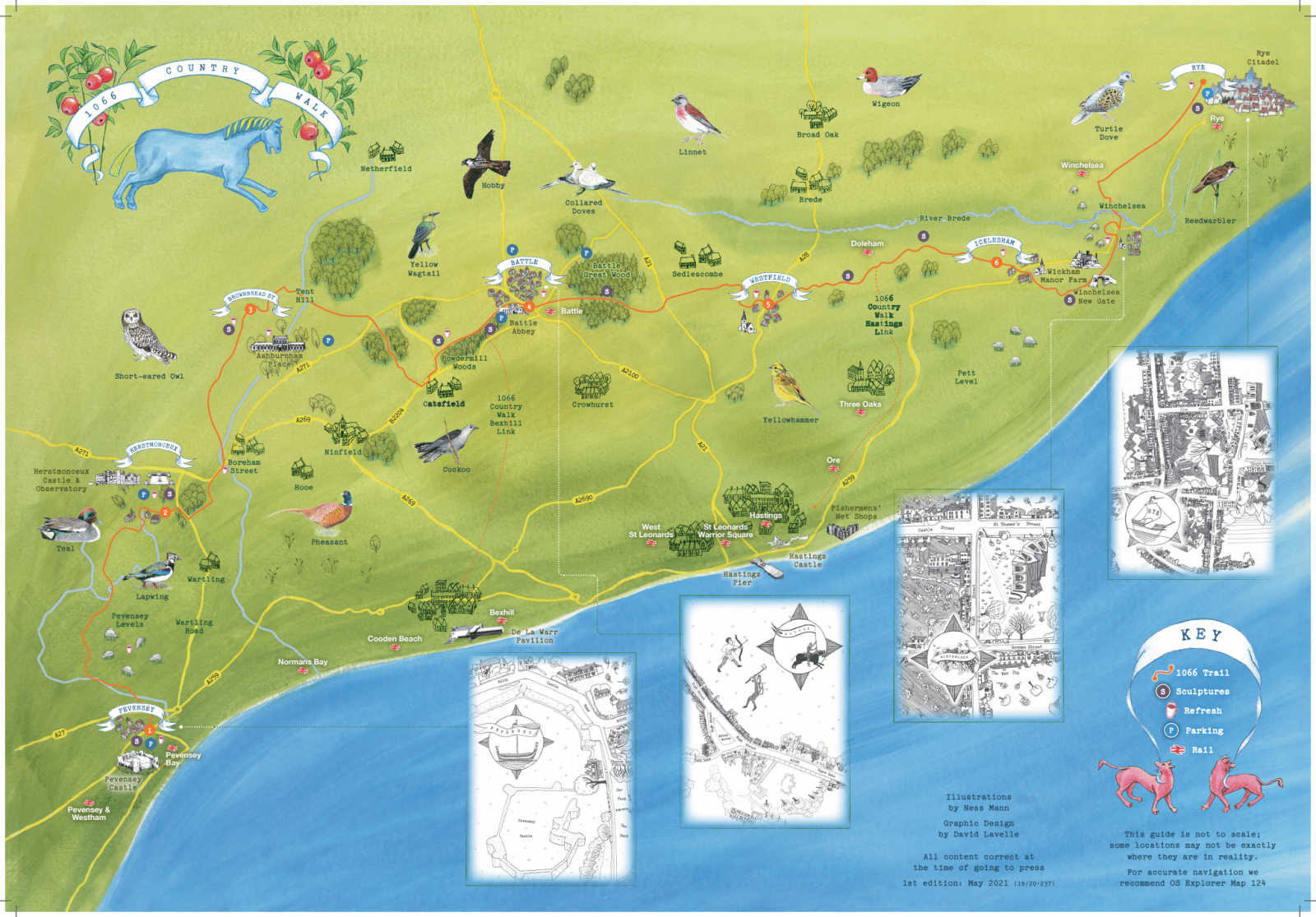
The 31-mile 1066 Country Walk is a relatively easy, low-level route through countryside that witnessed the Norman Conquest. Starting at Pevensey Castle (and heading north towards the Pevensey levels), it passes Herstmonceux Castle, the historic 1066 Battle Abbey and Battlefield, medieval Winchelsea, ending in historic Rye.
Thanks to a grant of £160,000 secured from the European Agricultural Fund for Rural Development by Rother District Council Cultural Development, the 1066 Country Walk has been improved with new signage, information panels, benches and sculptures in situ.
Much of the walk passes through the High Weald Area of Outstanding Natural Beauty, a typical medieval landscape with rolling hills and valleys, atmospheric marshes, ancient woodland, historic towns, quaint villages, old churches, rustic farms, elegant estates, oast houses and windmills, and plenty of cosy pubs and cafés along the way.
Pevensey Start/End point: Pevensey Castle, Castle Road, Westham, Pevensey, BN24 5LE. Starting from the sculpture within the castle, take a left out of the castle gates and cross the road. A minute down Castle Road you will see a small pathway on your right. Look out for the 1066 Country Walk discs here. This heads off towards the Pevensey Levels. Please note that very soon you will need to cross the busy A27 Pevensey Bypass so dogs must be kept on leads and we advise childrens hands are held on this approach.
Rye Start/End point: West Undercliff, off Udimore Road, Rye, TN31 7DX (near Gibbet Marsh car park). The start of the footpath is at the junction where Udimore Road meets West Undercliff. Lookout for the 1066 Country Walk discs and the Southern Water gate.
Used as a case study for best practice by Natural England and recommended by walkers themselves, we hope you’ll give the 1066 Country Walk a go!
Review
"What a great walk it was and how impressed I was with the signage and upkeep of the pathways. With the occasional consult of the OS map the way was well signposted. I was a lone female doing the walk but I felt quite safe, as it was clear where I was going". – Jan, Wadhurst
This breaks the walk into six easy sections, each of which takes 3-4 hours. This is intended be used in conjunction with OS Map 124.
Or why not make a longer break of it? There are plenty of places to stay along the route.
There are a number of busy roads that need to be crossed along the route, most notably the A27 and A21. Please take extra care if walking with children and ensure dogs are kept on leads as you approach these points.
Dogs must be kept on leads when crossing farmland. Do not approach any injured farm animals but please report them to the nearest farm or contact the RSPCA. For any injured wildlife contact East Sussex Wildlife Rescue.
Please take all litter home with you.
Created by local artist Keith Pettit, the ten wooden sculptures along the Walk are inspired by the Bayeux Tapestry and the heritage of 1066 Country.
The ten sculptures in order of location from Pevensey to Rye:
Landings
Norman Longboat at Pevensey Castle (accessible by wheelchair)
OS Map ref: TQ 64575 04809 | what3words.com/dolphins.warping.apprehend
Isti Mirant Stella
Halley’s Comet crossed the sky just before the invasion, Herstmonceux Castle (accessible by wheelchair)
OS Map ref: TQ 65131 10211 | what3words.com/boarded.ditching.remains
Rest
The horses that played a vital role in the invasion, Ash Tree Inn, Ashburnham
OS Map ref: TQ 67593 114876 | what3words.com/remit.mercy.wobbling
Window
The animals depicted in the border of the Bayeux Tapestry, beside Great Park Farm (accessible by wheelchair)
OS Map ref: TQ 72697 14575 | what3words.com/blurs.unhelpful.assure
Bound Division
King Harold, King William and the Crown, hidden in trees by the path, outside Battle Abbey
OS Map ref: TQ 74465 15645 | what3words.com/nightlife.training.heartened
Hidden Truth
The crown over which the battle was fought, Battle Great Woods
TQ 574505 15682 | what3words.com/repeating.handy.settle
Farbanks Henge
Monoliths overlook the Normans’ new realm, Pattletons Farm, Westfield
OS Map ref: TQ 83095 16185 | what3words.com/pipe.robe.rich
Legacies
Saxon and Norman roots entwine in the English language, Lower Snailham Farm, Guestling
OS Map ref: TQ 83110 16162 | what3words.com/handlebar.attention.robe
The Watcher
A sentry watching for the arriving Norman fleet, Wickham Manor Farm, Winchelsea
OS Map ref: TQ 89825 16405 | what3words.com/eyelash.fabric.tower
Treow (Old English for Tree)
A Bayeux Tapestry tree, start of the path at Rye (accessible by wheelchair)
OS Map ref: TQ 91303 20241 | what3words.com/impaired.defeat.something
Images above are shown in this order. All photographs by Jim Holden
Look out for the annual 1066 Country Walk Puddings and Pathways Festival - free professional street theatre at eateries on various dates along the route.
1066 Puddings
You’ll also find delicious 1066 themed puddings at eateries along the route, which raises the question ‘how many puddings can you eat in one walk?’
List coming soon…

15 October 2021: 1066 Country Walk relaunches
1 December 2020: 1066 Country Walk sculptures take their place
18 June 2020: First sculpture completed for 1066 Country Walk makeover
5 March 2020: Historic route gets major facelift to boost tourism and business
